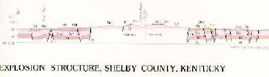
Interstate 64 passes through the rim of this crater about 5 miles southeast of Shelbyville, near mile marker 38. The crater originally has a 6600 ft diameter, a depth of 920 feet, and a rim height of 290 ft (C. Ronald Seeger, Kentucky Geological Survey reprint 28, 1969). The following map and cross section are from Cressman (1981, Geological Survey Professional Paper 1151-B). In the map I64 is the pair of dark lines running across the bottom.
The following is a cross section through Jeptha Knob, showing the obliteration of the subsurface layering below the impact.